Re: V8 engine castings
Posted by Mr.Pushbutton On 2010/8/19 13:03:42
More fuel for the fire: the plant area in 1952:clas.wayne.edu/photos/part2/wayne/1952/de-29-23.pdf
And in 1956:clas.wayne.edu/photos/part2/wayne/1956/ga-1-74.pdf
And in 1961, I-94 being completed through this part of town:clas.wayne.edu/photos/part2/wayne/1961/fm-30-129.pdf
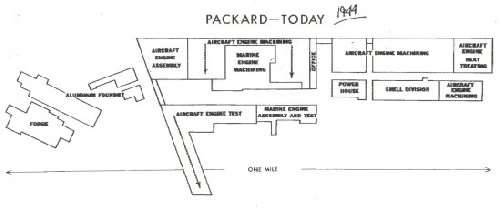
It looks like the Forge works and foundry were not affected by the construction of the expressway, the footprint of the foundry operations can be seen (freshly cleared) in the 1961 photo, so apparently Packard sold the land outright and it was cleared sometime before the 1961 picture was taken. So I take back what I said about the Expressway taking the foundry operations.
That same area today:
<iframe width="425" height="350" frameborder="0" scrolling="no" marginheight="0" marginwidth="0" src="http://maps.google.com/maps?f=q&source=s_q&hl=en&geocode=&q=1580+East+Grand+Boulevard,+Detroit,+MI&sll=37.0625,-95.677068&sspn=37.136668,54.84375&ie=UTF8&hq=&hnear=1580+E+Grand+Blvd,+Detroit,+Wayne,+Michigan+48211&ll=42.378539,-83.027755&spn=0.002116,0.003347&t=h&z=14&output=embed"></iframe><br /><small><a href="http://maps.google.com/maps?f=q&source=embed&hl=en&geocode=&q=1580+East+Grand+Boulevard,+Detroit,+MI&sll=37.0625,-95.677068&sspn=37.136668,54.84375&ie=UTF8&hq=&hnear=1580+E+Grand+Blvd,+Detroit,+Wayne,+Michigan+48211&ll=42.378539,-83.027755&spn=0.002116,0.003347&t=h&z=14" style="color:#0000FF;text-align:left">View Larger Map</a></small>
Attach file:
 (12.88 KB)
And in 1956:clas.wayne.edu/photos/part2/wayne/1956/ga-1-74.pdf
And in 1961, I-94 being completed through this part of town:clas.wayne.edu/photos/part2/wayne/1961/fm-30-129.pdf
It looks like the Forge works and foundry were not affected by the construction of the expressway, the footprint of the foundry operations can be seen (freshly cleared) in the 1961 photo, so apparently Packard sold the land outright and it was cleared sometime before the 1961 picture was taken. So I take back what I said about the Expressway taking the foundry operations.
That same area today:
<iframe width="425" height="350" frameborder="0" scrolling="no" marginheight="0" marginwidth="0" src="http://maps.google.com/maps?f=q&source=s_q&hl=en&geocode=&q=1580+East+Grand+Boulevard,+Detroit,+MI&sll=37.0625,-95.677068&sspn=37.136668,54.84375&ie=UTF8&hq=&hnear=1580+E+Grand+Blvd,+Detroit,+Wayne,+Michigan+48211&ll=42.378539,-83.027755&spn=0.002116,0.003347&t=h&z=14&output=embed"></iframe><br /><small><a href="http://maps.google.com/maps?f=q&source=embed&hl=en&geocode=&q=1580+East+Grand+Boulevard,+Detroit,+MI&sll=37.0625,-95.677068&sspn=37.136668,54.84375&ie=UTF8&hq=&hnear=1580+E+Grand+Blvd,+Detroit,+Wayne,+Michigan+48211&ll=42.378539,-83.027755&spn=0.002116,0.003347&t=h&z=14" style="color:#0000FF;text-align:left">View Larger Map</a></small>
Attach file:
(12.88 KB)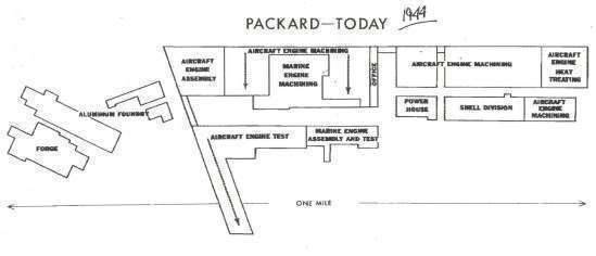
This Post was from: https://packardinfo.com/xoops/html/modules/newbb/viewtopic.php?post_id=58161