Re: Packard Plant: Aerial Photos - Dec 2011
Posted by RogerDetroit On 2011/12/6 12:46:54
Not only was Packard a big place, but so was Detroit. In the mid-1950's the population inside the boundaries of Detroit was 1,800,000 - today that number is 714,000. We've lost more people than most cities have people.
True, EGB was a major East/West artery, so was Harper Ave. running parallel to the north of EGB and Warren Rd. to the south.
Below is an aerial from Google Earth I use to demostrate the loss of population from Detroit to the suburbs. It is the neighborhood I grew up in, about 3.5 miles east of the PMCC. Today, not a single home remains on my block.
The N/S street in the center is Alter Road - the boundary line between the City of Detroit and Grosse Pointe Park. The E/W street in the center is Kercheval Street - notice Conner Avenue in the far left of the photo.
Now notice how much open space there is to the west(Detroit side) of Alter Road. Compare that with the roof-dotted area to the east (Grosse Pointe Park side) of Alter Rd. going a little more east you see the darker green area of the larger homes/lots of the City of Grosse Pointe.
Detroit cover 139 square miles and currently 43 square miles are vacant - about the land area of Boston. Some parts of the city have been described by The Detroit Free Press as an "Urban Prairie." And it did not have to be that way.
Attach file:
 (123.77 KB)

True, EGB was a major East/West artery, so was Harper Ave. running parallel to the north of EGB and Warren Rd. to the south.
Below is an aerial from Google Earth I use to demostrate the loss of population from Detroit to the suburbs. It is the neighborhood I grew up in, about 3.5 miles east of the PMCC. Today, not a single home remains on my block.
The N/S street in the center is Alter Road - the boundary line between the City of Detroit and Grosse Pointe Park. The E/W street in the center is Kercheval Street - notice Conner Avenue in the far left of the photo.
Now notice how much open space there is to the west(Detroit side) of Alter Road. Compare that with the roof-dotted area to the east (Grosse Pointe Park side) of Alter Rd. going a little more east you see the darker green area of the larger homes/lots of the City of Grosse Pointe.
Detroit cover 139 square miles and currently 43 square miles are vacant - about the land area of Boston. Some parts of the city have been described by The Detroit Free Press as an "Urban Prairie." And it did not have to be that way.
Attach file:
(123.77 KB)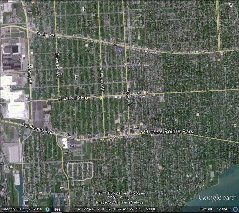
This Post was from: https://packardinfo.com/xoops/html/modules/newbb/viewtopic.php?post_id=90830