|
Re: Packard Plant: Aerial Photos - Dec 2011
|
||||
|---|---|---|---|---|
|
Home away from home
|
Not only was Packard a big place, but so was Detroit. In the mid-1950's the population inside the boundaries of Detroit was 1,800,000 - today that number is 714,000. We've lost more people than most cities have people.
True, EGB was a major East/West artery, so was Harper Ave. running parallel to the north of EGB and Warren Rd. to the south. Below is an aerial from Google Earth I use to demostrate the loss of population from Detroit to the suburbs. It is the neighborhood I grew up in, about 3.5 miles east of the PMCC. Today, not a single home remains on my block. The N/S street in the center is Alter Road - the boundary line between the City of Detroit and Grosse Pointe Park. The E/W street in the center is Kercheval Street - notice Conner Avenue in the far left of the photo. Now notice how much open space there is to the west(Detroit side) of Alter Road. Compare that with the roof-dotted area to the east (Grosse Pointe Park side) of Alter Rd. going a little more east you see the darker green area of the larger homes/lots of the City of Grosse Pointe. Detroit cover 139 square miles and currently 43 square miles are vacant - about the land area of Boston. Some parts of the city have been described by The Detroit Free Press as an "Urban Prairie." And it did not have to be that way. Attach file:  (123.77 KB) (123.77 KB)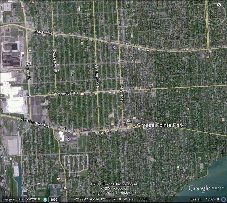
Posted on: 2011/12/6 12:46
|
|||
|
||||
|
Re: Packard Plant: Aerial Photos - Dec 2011
|
||||
|---|---|---|---|---|
|
Home away from home
|
That is so sad.
I've a friend with a sister living in Detroit. When he came back from last year's visit there he stopped by while I was watching a program about Berlin, Germany in the 1950's. I hit the mute button when he came in and after a bit he noticed the some of the pictures on the screen and asked in all seriousness if the TV program was about Detroit. I told him it was about Post War Berlin; to which he responded - "Looks like Detroit to me".
Posted on: 2011/12/6 14:09
|
|||
|
1951 200 Deluxe Touring Sedan
1951 200 Deluxe Touring Sedan (parts ?) 1951 Patrician Touring Sedan 1955 Patrician Touring Sedan |
||||
|
||||
|
Re: Packard Plant: Aerial Photos - Dec 2011
|
||||
|---|---|---|---|---|
|
Home away from home

|
When was the Edsel Ford Freeway built? I ask because it seems that time was against the old EGB plant. Had Packard stayed rather than moved to Conner and had they survived the Fifties, would they have been forced out soon after anyway?
It's incredible what happened to our cities. In the first half of the 20th Century they grew with careful planning and thought and were a model of good design and efficiency. Then in the last half of the century all those carefully laid plans got thrown in the dumpster. City planners and architects were replaced with highway engineers and suburban developers and we undid or walked away from everything we long labored to create.
Posted on: 2011/12/12 16:42
|
|||
|
||||
|
Re: Packard Plant: Aerial Photos - Dec 2011
|
||||
|---|---|---|---|---|
|
Home away from home
|
Hello Paul:
The interchange of I-94 (Edsel Ford Expressway) and the John Lodge Expressway was completed in 1953 and work proceeded eastward toward the PMCC from there. More than 10 years later I-94 terminated at the City of Detroit boundry to the east. It wasn't until after 1965 that I-94 went out into the eastern suburbs. I my humble opinion, the problem was not with land planners, architects, engineers or developers - it was with corrupt and mindless, power-hungry politicians.
Posted on: 2011/12/12 20:26
|
|||
|
||||


